Canada's top ten weather stories of 2013
- 2013 - A Year in Review
- 1. Alberta's Flood of Floods
- 2. Toronto's Torrent
- 3. Bumper Crops in the West, So-So for the Rest
- 4. The Nightmare during Christmas
- 5. To Flood or Not to Flood?
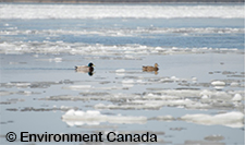
- 6. Rebound in the Arctic Ocean and the Great Lakes
- 7. Wicked Winter Weather Wallops the East
- 8. Spring Flooding in Ontario’s Cottage Country
- 9. Prairie Winter Went on Forever
- 10. Stormy Seas and Maritime Tragedy
- Runner-up Stories
- Atlantic Regional Highlights
- Quebec - Regional Highlights
- Ontario - Regional Highlights
- Prairie Provinces - Regional Highlights
- British Columbia - Regional Highlights
- The North - Regional Highlights
5. To Flood or Not to Flood?

At the beginning of March, flood forecasters in Manitoba and Saskatchewan were worried that a record snowpack (triple the average in some places), thick river ice and a slower-than-normal thaw would collectively raise the flood threat. Whether the Red River Valley would be facing its third major flood in five years was up to yet-to-be-determined factors such as spring storms and the phasing of overland snowmelt with the ice break-up in ditches and rivers. On a positive note, there was less moisture in the soil when the ground froze the previous fall, meaning it had more capacity to absorb the runoff from the spring snowmelt. Flood fears continued to grow as stubborn winter weather lingered well into spring. By mid-April at least 70 per cent of the ground was still covered with snow. Further, spring snows were high in water content and were twice normal accumulations across the American/Canadian portions of the Red River Basin. Temperatures in March and April (barely above freezing during the day and frigid at night), were the coldest in 16 years, slowing the spring melt considerably and worsening the flood outlook along the Red, Assiniboine, Pembina, Souris and Qu’Appelle rivers.
With Prairie rivers expected to peak about two to three weeks later than usual, officials were not sure what to wish for. On the one hand, a warm spring would get rid of the snow and ice before late April rain showers. A delayed thaw increases the risk of triggering a sudden and inevitable warm-up, ensuing melt, possible ice jamming, spring rains and an instant freshet. On the other hand, a cold spring can ease flooding by slowing the melt and letting melt water move gradually through the system. The water is more likely to move in stages – slowly overland, into ditches and rivers, out through tributaries and into the main, rather than all at once.
As it turned out, the potential epic flood didn’t happen. The insufferably frigid spring that Prairie residents had been cursing actually worked in their favour. The cold days and very cold nights slowed the disappearance of the late record snowpack, which had a calming effect, allowing a slow, gradual melt. Main rivers started flowing before their tributaries came rushing in, Canadian rivers ran their course before water from American watersheds arrived and multiple melt-stages instead of one large gush of water combined to deliver the best possible news.
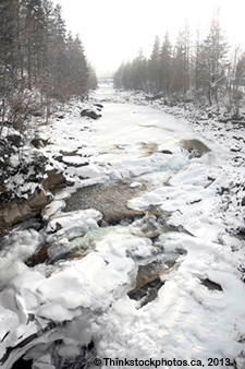
By early May, the worst of the flood threat seemed to be over. River flow got underway as water levels in most tributaries were declining. A lot of snow simply evaporated or disappeared through sublimation, while melt water was absorbed by the ground. In addition, rivers were ice free and controlled river diversions helped eased the flood threat. While water levels were high in some regions, flood risks were certainly much lower than predicted only three weeks earlier and any flooding that did happen was manageable. That didn’t mean hard work and hardship were absent. Dire forecasts prompted communities from North Battleford to Winnipeg to rush preparations for the coming flood. Volunteers filled millions of bags with sand and dozens of Tiger dams (large flexible containers) with water. Work teams cleared culverts and catch basins, laid sandbags, dug channels, rerouted water and corralled the runoff with air-filled booms. Provincial water agencies also released more water from reservoirs to make room for the spring runoff.
Several dozen people had to leave their homes in First Nations communities across Saskatchewan and Manitoba. At times, roads were covered with water or washed out. Pumps worked continuously. In Saskatchewan, 14 communities were under states of emergency compared to 60 in 2011. Flood waters were blamed for a passenger train derailment in eastern Saskatchewan and closed a stretch of the Trans-Canada Highway between Indian Head and Whitewood, and the Yellowhead Highway near Radisson. The final disruption was a delay in seeding for farmers who had to wait several weeks for waterlogged fields to drain.
- Date modified: